Are you tired of relying on the ancient art of reading maps or, heaven forbid, asking for directions? We have the best handheld GPS devices and apps to guide you through your adventures with ease.
Whether you’re a nature enthusiast, a thrill-seeker, or simply someone who loves exploring, these navigation tools will become your trusted companions. From the Garmin eTrex SE GPS Handheld Navigator to the Garmin Montana 700 Rugged GPS Touchscreen Navigator, we have carefully reviewed and selected the top picks just for you.
Get ready to embark on your next great journey with confidence, as we unveil the best handheld GPS devices and apps of 2025. Belong to the future of navigation and never lose your way again.
Best Handheld GPS devices and apps for navigation in 2025
8. Garmin eTrex SE GPS Handheld Navigator
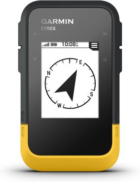
If you’re looking for a reliable handheld GPS device for navigation in 2025, the Garmin eTrex SE is packed with features to enhance your outdoor adventures.
With a long battery life of up to 168 hours in standard mode and up to 1,800 hours in expedition mode, you can rely on this device for extended trips. The 2.2′ high-resolution display provides clear visibility of waypoints and your current location.
The eTrex SE also offers wireless connectivity with the Garmin Explore app, allowing for software updates, trip planning, smart notifications, and additional mapping. It supports multi-GNSS tracking, ensuring accurate location information even in challenging environments.
The water-resistant design further adds to its durability. With a digital compass, you can have accurate heading information even when stationary.
- Long battery life for extended trips
- Wireless connectivity with Garmin Explore app
- Multi-GNSS support for accurate tracking
- Water-resistant design for durability
- Digital compass for accurate heading
- User interface and documentation could be improved
- Some users experienced issues with Bluetooth connectivity
- Limited screen visibility in direct sunlight
7. Garmin GPSMAP 67 Rugged GPS Handheld
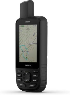
The Garmin GPSMAP 67 Rugged GPS Handheld offers enhanced accuracy with its expanded GNSS and multi-band technology. With a large 3′ sunlight-readable color display, this handheld device provides clear and detailed navigation information. It also includes a 3-axis compass and barometric altimeter for precise navigation.
The GPSMAP 67 Rugged GPS Handheld features wireless connectivity for weather updates and Geocaching Live. Additionally, it can be used with the Garmin Explore website or app for trip planning and access to premium mapping content with an Outdoor Maps+ subscription.
- Expanded GNSS and multi-band technology for enhanced accuracy
- Large sunlight-readable color display for clear navigation information
- 3-axis compass and barometric altimeter for precise navigation
- Wireless connectivity for weather updates and Geocaching Live
- Compatibility with Garmin Explore for trip planning and access to premium mapping content
- The learning curve for the interface may be steep
- Some users reported software crashes in the satellite menu
- The built-in battery may not be convenient for all users, and lack of a charger is a downside
6. Garmin Montana 700 Rugged GPS Touchscreen Navigator
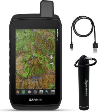
Get precise and reliable navigation with the Garmin Montana 700 Rugged GPS Touchscreen Navigator, equipped with a range of features to enhance your outdoor adventures.
This handheld GPS device offers a 5′ glove-friendly touchscreen display, making it easy to navigate even in challenging conditions. It also boasts multi-GNSS support, including GPS, GLONASS, and Galileo, ensuring accurate positioning wherever you go.
With preloaded TopoActive maps and outdoor navigation sensors like a 3-axis compass and barometric altimeter, you can confidently explore new territories. The Garmin Montana 700 is pro-connected, offering ANT+ technology, Wi-Fi connectivity, and Bluetooth wireless networking for seamless data sharing.
However, some users have reported difficulties customizing the home screen and issues with touch performance and power buttons. Overall, the Garmin Montana 700 is a reliable choice for outdoor enthusiasts seeking advanced navigation capabilities.
- Rugged construction rated to MIL-STD 810
- Large glove-friendly touchscreen display
- Multi-GNSS support for accurate positioning
- Preloaded TopoActive maps
- Outdoor navigation sensors (3-axis compass and barometric altimeter)
- Pro-connected with ANT+ technology, Wi-Fi, and Bluetooth connectivity
- Difficulty customizing the home screen
- Issues with touch performance and power button
- Glass screen protector and rubberized case may interfere with controls
5. Garmin GPSMAP 66s, Rugged Multisatellite Handheld
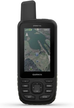
You’ll appreciate the ruggedness and multi-satellite capabilities of the Garmin GPSMAP 66s, a top choice for handheld GPS devices and apps for navigation in 2025.
With its large, 3” sunlight-readable color display, you can easily view maps and navigate through various terrains. The GPSMAP 66s supports multiple Global Navigation Satellite Systems (GNSS), ensuring accurate positioning even in challenging environments. It also features a three-axis compass and barometric altimeter, providing additional navigational tools.
The device comes with preloaded TOPO U.S. and Canada maps, and you can access BirdsEye Satellite Imagery with direct-to-device downloads. The expanded wireless connectivity allows you to stay updated with Active Weather and Geocaching Live. The Garmin GPSMAP 66s is also compatible with Garmin Explore, offering advanced route planning and tracking features.
- Rugged design for durability in outdoor environments
- Multiple GNSS support for accurate positioning
- Large, sunlight-readable display for easy map viewing
- Preloaded TOPO U.S. and Canada maps
- Access to BirdsEye Satellite Imagery
- Short battery life
- Limited documentation
- Connectivity issues with certain apps
- Software glitches and updates needed
- Outdated BirdsEye data
4. Garmin Rugged Handheld GPS Navigator
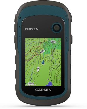
For rugged outdoor navigation in 2025, the Garmin Rugged Handheld GPS Navigator offers reliability and durability. With its 2.2′ sunlight-readable color display and preloaded Topo Active maps, this device is suitable for cycling, hiking, and other outdoor activities. It supports both GPS and GLONASS satellite systems, ensuring accurate positioning.
The 8 GB internal memory can be expanded with a micro SD card, providing ample storage space for maps and waypoints. The battery life of up to 25 hours in GPS mode with 2 AA batteries is impressive, making it ideal for extended outdoor adventures.
- Reliable and durable for rugged outdoor use
- Sunlight-readable color display for easy visibility
- Preloaded Topo Active maps for cycling and hiking
- Support for GPS and GLONASS satellite systems
- Expandable memory with micro SD card slot
- Long battery life of up to 25 hours in GPS mode
- No 3-axis compass or barometric altimeter
- The learning curve for navigation features
- Coordinate stability and accuracy could be improved compared to smartphones.
3. Garmin Montana 700, Rugged GPS Handheld
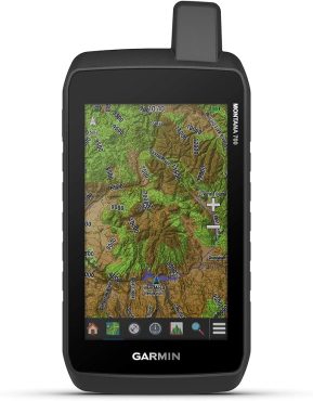
The Garmin Montana 700 is a rugged GPS handheld device that offers reliable navigation for outdoor adventures in 2025. With its 5′ glove-friendly touchscreen display and rugged construction rated to MIL-STD 810, this device is built to withstand thermal, shock, water, and vibration.
It features multi-GNSS support, including GPS, GLONASS, and Galileo, ensuring accurate positioning. The preloaded TopoActive maps provide detailed routable mapping for roads and trails, making it easy to navigate through various terrains.
Additionally, the Montana 700 is pro-connected with ANT+ technology, Wi-Fi connectivity, and Bluetooth wireless networking, allowing for direct-to-device access to BirdsEye Satellite Imagery downloads, location sharing, and Connect IQ app support.
- Rugged construction for durability
- Multi-GNSS support for accurate positioning
- Preloaded TopoActive maps for detailed navigation
- Pro-connected with ANT+ technology, Wi-Fi, and Bluetooth
- Learning curve for operation and touch screen use
- Street map issues reported by some users
- Emergency services behind a paywall
2. Garmin GPSMAP 66i, GPS Handheld
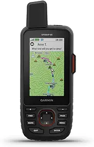
With its advanced satellite communication capabilities and extensive mapping features, the Garmin GPSMAP 66i is a top choice for outdoor enthusiasts in need of reliable navigation in 2025. This GPS handheld and satellite communicator boasts a large 3-inch sunlight-readable color display and comes preloaded with Garmin TOPO mapping and inReach technology. It allows for two-way messaging and interactive SOS alerts, ensuring that you can stay connected and safe even in remote areas.
The device supports multiple global navigation satellite systems (GNSS) and navigation sensors, offering accurate and precise positioning. Additionally, it offers cellular connectivity for weather forecasts and geocaching live. Compatible with the Garmin Explore website and app, managing waypoints, routes, activities, and collections is a breeze.
- Advanced satellite communication capabilities
- Extensive mapping features
- Two-way messaging and SOS alerts
- Multiple GNSS support
- Cellular connectivity for weather forecasts and geocaching live
- Compatibility with Garmin explore website and app
- Expensive compared to separate GPS and satellite communicator devices
- Costly payment plans and map options
- Limited compatibility with GLONASS due to Iridium satellite network constraints
1. Garmin Worldwide Handheld GPS Navigator
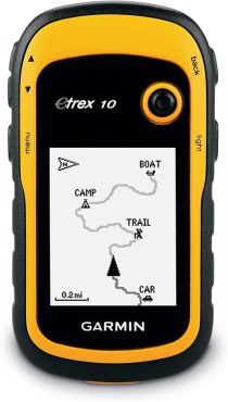
When considering the best handheld GPS devices and apps for navigation in 2025, you’ll find that the Garmin Worldwide Handheld GPS Navigator stands out for its reliable performance and extensive mapping capabilities.
This rugged handheld navigator comes preloaded with a worldwide base map and features a 2.2-inch monochrome display. With a WAAS-enabled GPS receiver and support for GLONASS, it offers fast positioning and a reliable signal. The device is also waterproof to IPX7 standards, protecting against splashes and rain. Additionally, it supports paperless geocaching and Garmin spine mounting accessories. Powered by two AA batteries, it offers up to 20 hours of use.
- Reliable performance and extensive mapping capabilities
- WAAS-enabled GPS receiver with fast positioning
- Waterproof to IPX7 standards
- A monochrome display may be less visually appealing
- Limited battery life compared to devices with rechargeable batteries
- Lack of advanced features like turn-by-turn instructions and map functionality
How to choose the best handheld GPS devices and apps for navigation
Map coverage and precision of directions
To choose the best handheld GPS device or app for navigation, consider the level of map coverage and the precision of directions it offers.
Map coverage refers to the extent of geographical areas that the device or app can accurately navigate. Look for devices or apps that provide comprehensive map coverage, including detailed maps of your desired locations and updates for new roads and landmarks.
The precision of directions is crucial for accurate navigation. The device or app should provide clear and concise instructions, with accurate turn-by-turn guidance and real-time updates on your current location. It should also have reliable signal reception and minimal lag time.
Ensure that the GPS device or app you choose has a reputation for providing accurate and reliable map coverage and precise directions to enhance your navigation experience.
Cost of maps and traffic data
To choose the best handheld GPS device or app for navigation, consider the cost of maps and traffic data.
The cost of maps and traffic data can vary depending on the device or app you choose. Some GPS devices or apps may require a one-time purchase for map updates, while others may offer a subscription-based model for accessing updated maps and traffic information.
It’s important to consider your budget and how often you’ll need to update the maps and traffic data. Additionally, some devices or apps may offer free map updates for a limited period or include lifetime map updates in the initial purchase price.
Evaluating the cost of maps and traffic data will help you choose a GPS device or app that fits your needs and budget.
Size of screen and ease of interface
For easy navigation, consider the size of the screen and the ease of the interface when choosing the best handheld GPS device or app in 2025.
The size of the screen is important because it determines how much information you can see at a glance. A larger screen allows for better visibility, making it easier to read maps and navigate through menus. On the other hand, a smaller screen may be more compact and portable, but it could also make it harder to read and interact with the device.
In terms of the interface, you want it to be intuitive and user-friendly, allowing you to easily access the features and functions you need. Look for devices and apps that have clear menus, responsive touchscreens, and customizable settings to enhance your navigation experience.
Wi-Fi, Bluetooth, and smartphone capability
When choosing the best handheld GPS devices and apps for navigation in 2025, it’s important to consider the Wi-Fi, Bluetooth, and smartphone capability as it can greatly enhance your navigation experience.
Wi-Fi capability allows you to connect to Wi-Fi networks and access online maps, weather updates, and other real-time information.
Bluetooth capability enables you to connect your GPS device to other Bluetooth-enabled devices, such as heart rate monitors or smartphones, for additional functionality and data sharing.
Smartphone capability allows you to connect your GPS device to your smartphone, giving you access to a wider range of navigation apps, including those that offer more detailed maps and advanced features.
Power Source and Battery Life
With the Wi-Fi, Bluetooth, and smartphone capabilities discussed, let’s now delve into the important aspect of power source and battery life when selecting the best handheld GPS devices and apps for navigation in 2025.
When it comes to power sources, consider whether the device uses disposable batteries or has a rechargeable battery. Rechargeable batteries are more convenient and cost-effective in the long run.
Additionally, pay attention to the battery life of the GPS device. Look for devices that offer longer battery life, especially if you plan on using them for extended periods or in remote areas without access to charging options.
Consider the activities you’ll be using the GPS device for and choose one with a battery life that suits your needs.
Conclusion
In conclusion, the best handheld GPS devices and apps for navigation in 2025 offer a reliable and user-friendly solution for outdoor adventurers. With advanced features, such as accurate mapping and long battery life, these tools ensure you never get lost in the wilderness.
Studies show that using GPS devices can reduce navigation errors by up to 90%. So, whether you choose a standalone GPS device or a smartphone app, rest assured that you’ll have the perfect companion for your outdoor explorations.
